You Invested in Snowflake.
Your Spatial Data Is Still Stuck.
Decision time: Weeks → Seconds
Data sources: 5+ → 1
"We are already on Snowflake, do we really need anything else?"
“Our GIS team already handles this."
"We do not have time for a big migration project."
We solve for access first. No rip and replace. No 18 month program.
What is Slowing You Down
Scattered across silos
Address data, flood models, trade areas, network assets - all living in different systems. Analysts spend more time hunting data than analysing it.
Slow and manual
Site selection that takes weeks. Underwriters waiting hours for a flood risk score. You know the data exists. It is just trapped.
Locked away from business users
Even when data reaches Snowflake, business users still cannot self-serve. Every question becomes a ticket. The bottleneck just moved.
What you actually want (and it is not "better GIS")
Decisions in minutes, not weeks.
Simple tools anyone can use.
Spatial and business data in one place, so there is one version of the truth.
How We Fix It
Two phases. Clear outcomes. No fluff
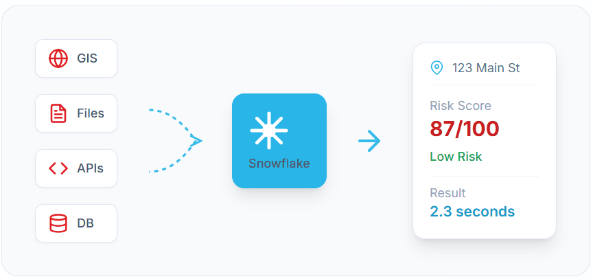
Get Your Spatial Data Flowing into Snowflake
We build automated FME pipelines that move your key spatial data - addresses, flood models, trade areas, assets - from legacy systems into Snowflake. No more manual exports. No more one-off scripts.
For data, analytics and GIS leaders who are done with silos and manual workarounds.
What you get:
Put Instant Answers in Business Users Hands
Once the data flows, we build simple web apps that turn spatial data into answers. Underwriters, site selectors and executives type an address and get an instant score or recommendation.
For teams who want to scale spatial insights without hiring more GIS staff.
What you get:
Built for Teams Where Location Drives Decisions
Underwriters type an address and see an instant risk score. Deals do not wait on a spreadsheet.
Catastrophe maps show which policyholders are impacted in real time so you can act first.
Site suitability scorecards: 0-100 score in seconds, not weeks of analysis.
See cannibalisation risk before you sign the lease.
Outage triage maps: prioritise repairs by customer impact and asset criticality.
Capital planning dashboards show where to spend next, based on evidence.
Instant property intelligence in one view: demographics, amenities, risks, recent sales.
Portfolio risk maps highlight problem assets before they become headlines.
Why Snowflake + Spatial Just Makes Sense
See Where Your Snowflake Spatial Strategy Stands (in 5 Minutes)
Instant email with your score and next steps. No sales call required.
Help Us Build the Spatial App You Actually Need
Join our co-design circle and share your biggest spatial headache. Your input determines our build priority, and you'll get first access to it.